KARTOGRAFISCH TIJDSCHRIFT
I996-XXII-2
J.B. Krygier C. Reeves (1992),
Animation and the Role of Map
Design in Scientific Visualisation.
Cartography and Geographie In-
formadon Systems, vol. 19, no. 4,
pp. 201-214.
[7] MacEachren, A.M. (1994), How
Maps Work: Issues in Representa
tion Design. New York: Guilford
Press.
Through animation Software a laboratory setup was construc-
ted to test the properties oft .animation with a number ofexpe-
rimental subjects. The results show that animations are best
suited for rendering temporal themes. Non-temporal themes
may be presented through animation technology, but can best
be enhanced by the use of the conventional graphical variables,
colour, gray scale, pattern, shape and size.
Resume
Summar y
M. Yaman O. Koop - Cartographic
animation in a theoretical framework
Keywords: semiology, animation, re-
search
The world of cartography is, increasingly,
being confronted with non-paper publi-
cation media for conveying spatial Infor
mation. This Situation neccesitates a
more fundamental research approach.
This article deals with the perceptual
properties of cartographic animation.
M. Yaman O. Koop - Animation cartographique dans un
cadre theorique
Mots-cles: semiologie, animation, recherche
La cartographie sera, de plus en plus, confrontee avec des media
sans support 'papier'pour transmettre des informations geograp-
hiques. Cette evolution rend necessaire des recherches fonda-
mentales approfondies.
L'article analyse les caracteristiques de pereeption de l'animation
cartographique lesquelles ont ete examinees dans un laboratoire
via un logiciel approprie, traitant de plusieurs sujets experimen-
taux. Les resultats indiquent que l'animation est bien adaptee
pour les themes temporeis. Des themes non-temporels peuvent
egalement etre representes par des variables graphiques tradi-
tionnelles telles que forme, couleurs, strueture, grandeur etc.
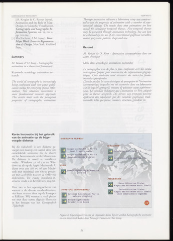
Körte Instructie bij het gebruik
van de animatie op de bijge-
voegde diskette
Bij dit tijdschrift is een diskette ge-
voegd met daarop een aantal door ons
ontwikkelde animaties die de ideeen
uit het bovenstaande artikel illustreren.
De diskette is zowel te installeren
onder Windows 3.1 of 3.11 en Win
dows 95 als op de Apple Macintosh. U
dient over een 386 PC of een Macin
tosh met minimaal een 68030 proces-
sor met 4 of 8Mb RAM en ca 7Mb vrije
diskruimte. De exaete installatie-in-
struetie vindt u in het fite lees_mij.txt.
Hier ziet u het openingsscherm van
waaruit u de diverse voorbeeldanima-
ties kunt starten door op de knoppen
te klikken. Wij wensen u veel plezier
toe met deze eerste digitale illustratie
in het bestaan van het Kartografisch
Tijdschrift.
WEERGA Vif MONENT
VOLGGRDE
Honger en Handel in Afrika
(met Transformatie)
Honger en Handel in Afrika
(met oplopende kleuren)
duur
Bevolkingomvang N-Amerika
per land
Bevolk
Hitbrei
Fft£OUENTIE
tW-TE VAN VERÄNDERUNG
Reistijd Amsterdam-Parijs
auto en vliegtuig
Bevolkingstoename
Frankrijk en Kenia
Desertification Status
Kayes and Velimane distr (Mali)
Desertification Status
Kayes and Yelimane distr. (Mali)
(met interactieve legende)
Figuur 6. Openingsscherm van de Animatie-demo bij het artikel Kartografische animatie
in een theoretisch kader door Mustafa Yaman en Olev Koop.
21