Lustrumboek "The 5th Element"
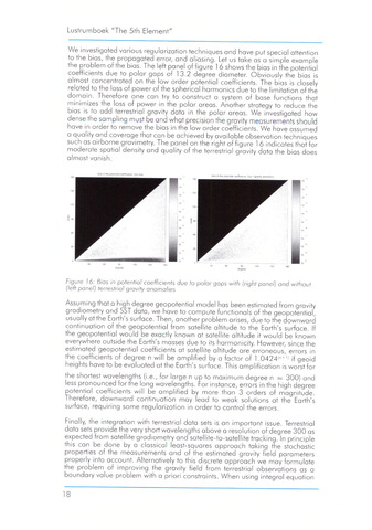
We investigated various regularization techniques and have put special attention
to the bias, the propagated error, and aliasing. Let us take as a simple example
the problem of the bias. The left panel of figure 1 6 shows the bias in the potential
coefficients due to polar gaps of 13.2 degree diameter. Obviously the bias is
almost concentrated on the low order potential coefficients. The bias is closely
related to the loss of power of the spherical harmonics due to the limitation of the
domain. Therefore one can try to construct a system of base functions that
minimizes the loss of power in the polar areas. Another strategy to reduce the
bias is to add terrestrial gravity data in the polar areas. We investigated how
dense the sampling must be and what precision the gravity measurements should
have in order to remove the bias in the low order coefficients. We have assumed
a quality and coverage that can be achieved by available observation techniques
such as airborne gravimetry. The panel on the right of figure 1 6 indicates that for
moderate spatial density and quality of the terrestrial gravity data the bias does
almost vanish.
Figure 16: Bias in potential coefficients due to polar gaps with (right panel) and without
(left panel) terrestrial gravity anomalies
Assuming that a high degree geopotential model has been estimated from gravity
gradiometry and SST data, we have to compute functionals of the geopotential,
usually at the Earth's surface. Then, another problem arises, due to the downward
continuation of the geopotential from satellite altitude to the Earth's surface. If
the geopotential would be exactly known at satellite altitude it would be known
everywhere outside the Earth's masses due to its harmonicity. However, since the
estimated geopotential coefficients at satellite altitude are erroneous, errors in
the coefficients of degree n will be amplified by a factor of 1.0424(n+1) if geoid
heights have to be evaluated at the Earth's surface. This amplification is worst for
the shortest wavelenaths (i.e., for large n up to maximum degree n 300) and
less pronounced for the long wavelengths. For instance, errors in the high degree
potential coefficients will be amplified by more than 3 orders of magnitude.
Therefore, downward continuation may lead to weak solutions at the Earth's
surface, requiring some regularization in order to control the errors.
Finally, the integration with terrestrial data sets is an important issue. Terrestrial
data sets provide the very short wavelengths above a resolution of degree 300 as
expected from satellite gradiometry and satellite-to-satellite tracking. In principle
this can be done by a classical least-squares approach taking the stochastic
properties of the measurements and of the estimated gravity field parameters
properly into account. Alternatively to this discrete approach we may formulate
the problem of improving the gravity field from terrestrial observations as a
boundary value problem with a priori constraints. When using integral equation
18